![](/images/other/stat-length.png)
![Tocht Stappen Valkenburg aan de Geul - Peerkepad rondwandeling EXTRA 1 - 25km. - Photo](https://media.geolcdn.com/t/1900/400/ext.pjpeg?maxdim=2&url=https%3A%2F%2Fstatic1.geolcdn.com%2Fsiteimages%2Fupload%2Ffiles%2F1553511878bg_sport_marche.png)
Peerkepad rondwandeling EXTRA 1 - 25km.
flip96
Gebruiker
![Lengte](/images/other/stat-length.png)
Lengte
25 km
![Max. hoogte](https://static1.geolcdn.com/siteimages/upload/files/1508320355ic_sort_altitude_max_24dp.png)
Max. hoogte
151 m
![Positief hoogteverschil](https://static1.geolcdn.com/siteimages/upload/files/1508320355ic_sort_den_pos_24dp.png)
Positief hoogteverschil
495 m
![Km-Effort](/images/other/stat-length.png)
Km-Effort
31 km
![Min. hoogte](https://static1.geolcdn.com/siteimages/upload/files/1508320355ic_sort_altitude_min_24dp.png)
Min. hoogte
51 m
![Negatief hoogteverschil](https://static1.geolcdn.com/siteimages/upload/files/1508320355ic_sort_den_neg_24dp.png)
Negatief hoogteverschil
495 m
![Boucle](https://static1.geolcdn.com/siteimages/upload/files/16400158638029165_repeat_loop_refresh_sync_direction_icon.png)
Boucle
Ja
Datum van aanmaak :
2020-01-04 14:16:05.321
Laatste wijziging :
2020-01-06 09:26:19.297
![Stappen](https://static1.geolcdn.com/sitytour/trail-icons/101.png)
7h05
Moeilijkheid : Zeer moeilijk
![Scan deze QR-code om de tocht te openen in de SityTrail-applicatie](https://capi.geolives.com/qq0zvz2zws4bq2lad0pu/sitytour/trails/2296704/qr.png?size=200)
Gratisgps-wandelapplicatie
Over ons
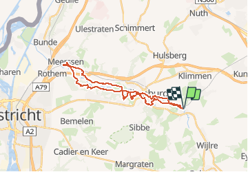
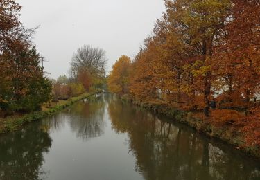
Tocht Stappen van 25 km beschikbaar op Limburg, Onbekend, Valkenburg aan de Geul. Deze tocht wordt voorgesteld door flip96.
Beschrijving
Eerste EXTRA rondwandeling Peerkepad. Tussen Schin op Geul en Meerssen.
25km. Ca. 500 meter stijging/afdaling.
Route is NIET gemarkeerd.
Plaatsbepaling
Land:
Netherlands
Regio :
Limburg
Departement/Provincie :
Onbekend
Gemeente :
Valkenburg aan de Geul
Locatie:
Unknown
Vertrek:(Dec)
Vertrek:(UTM)
702075 ; 5637630 (31U) N.
Opmerkingen
Wandeltochten in de omgeving
![Tocht Stappen Valkenburg aan de Geul - 🎅🎄 Valkenburg - Photo](https://media.geolcdn.com/t/375/260/ext.jpg?maxdim=2&url=https%3A%2F%2Fmedia.geolcdn.com%2Ff%2Fc3fac4ca-18c6-41ea-bd7c-d2a8e36eb914.jpg)
![Stappen Stappen](https://static1.geolcdn.com/sitytour/trail-icons/101.png)
🎅🎄 Valkenburg
Stappen
Gemakkelijk
(1)
Valkenburg aan de Geul,
Limburg,
Onbekend,
Netherlands
![](/images/other/stat-length.png)
4,2 km | 4,8 km-effort
1h 5min
![](https://static1.geolcdn.com/siteimages/upload/files/16400158638029165_repeat_loop_refresh_sync_direction_icon.png)
Ja
![Tocht Stappen Valkenburg aan de Geul - Sibbe - Valkenburg 🎄🎅 - Photo](https://media.geolcdn.com/t/375/260/ext.jpg?maxdim=2&url=https%3A%2F%2Fmedia.geolcdn.com%2Ff%2F635f6fea-be0e-416f-bbe0-3fc5facaae54.jpg)
![Stappen Stappen](https://static1.geolcdn.com/sitytour/trail-icons/101.png)
Sibbe - Valkenburg 🎄🎅
Stappen
Medium
(1)
Valkenburg aan de Geul,
Limburg,
Onbekend,
Netherlands
![](/images/other/stat-length.png)
10,4 km | 13,1 km-effort
2h 59min
![](https://static1.geolcdn.com/siteimages/upload/files/16400158638029165_repeat_loop_refresh_sync_direction_icon.png)
Ja
![Tocht Stappen Valkenburg aan de Geul - 2022-11-11_17h59m47_hoogtewandeling-valkenburg-aan-de-geul - Photo](https://media.geolcdn.com/t/375/260/ext.jpg?maxdim=2&url=https%3A%2F%2Fmedia.geolcdn.com%2Ff%2F17d77ae4-7009-4034-91af-70d2fca6ac04.jpg)
![Stappen Stappen](https://static1.geolcdn.com/sitytour/trail-icons/101.png)
2022-11-11_17h59m47_hoogtewandeling-valkenburg-aan-de-geul
Stappen
Medium
(2)
Valkenburg aan de Geul,
Limburg,
Onbekend,
Netherlands
![](/images/other/stat-length.png)
15,9 km | 21 km-effort
4h 44min
![](https://static1.geolcdn.com/siteimages/upload/files/16400158638029165_repeat_loop_refresh_sync_direction_icon.png)
Ja
![Tocht Stappen Gulpen-Wittem - 2021-11-26_14h13m03_1450 (2) - Photo](https://media.geolcdn.com/t/375/260/ext.jpg?maxdim=2&url=https%3A%2F%2Fmedia.geolcdn.com%2Ff%2Fc6f56cbd-561d-45be-8633-9d909ae47436.jpg)
![Stappen Stappen](https://static1.geolcdn.com/sitytour/trail-icons/101.png)
2021-11-26_14h13m03_1450 (2)
Stappen
Gemakkelijk
(1)
Gulpen-Wittem,
Limburg,
Onbekend,
Netherlands
![](/images/other/stat-length.png)
10,6 km | 12,5 km-effort
2h 50min
![](https://static1.geolcdn.com/siteimages/upload/files/16400158638029165_repeat_loop_refresh_sync_direction_icon.png)
Ja
![Tocht Stappen Gulpen-Wittem - 2021-10-27_21h13m45_1225 - Photo](https://media.geolcdn.com/t/375/260/ext.jpg?maxdim=2&url=https%3A%2F%2Fmedia.geolcdn.com%2Ff%2F5eb7c815-cdad-419c-9110-728d3ac43338.jpg)
![Stappen Stappen](https://static1.geolcdn.com/sitytour/trail-icons/101.png)
2021-10-27_21h13m45_1225
Stappen
Gemakkelijk
(1)
Gulpen-Wittem,
Limburg,
Onbekend,
Netherlands
![](/images/other/stat-length.png)
13,7 km | 16,5 km-effort
3h 45min
![](https://static1.geolcdn.com/siteimages/upload/files/16400158638029165_repeat_loop_refresh_sync_direction_icon.png)
Ja
![Tocht Stappen Gulpen-Wittem - 2021-10-27_20h47m33_1105 - Photo](https://media.geolcdn.com/t/375/260/ext.jpg?maxdim=2&url=https%3A%2F%2Fmedia.geolcdn.com%2Ff%2F115742d6-93f7-467f-9808-8e4bc3de0870.jpg)
![Stappen Stappen](https://static1.geolcdn.com/sitytour/trail-icons/101.png)
2021-10-27_20h47m33_1105
Stappen
Gemakkelijk
(1)
Gulpen-Wittem,
Limburg,
Onbekend,
Netherlands
![](/images/other/stat-length.png)
13,3 km | 15,7 km-effort
3h 34min
![](https://static1.geolcdn.com/siteimages/upload/files/16400158638029165_repeat_loop_refresh_sync_direction_icon.png)
Ja
![Tocht Stappen Valkenburg aan de Geul - 2021-07-31_16h24m37_668 (1) - Photo](https://media.geolcdn.com/t/375/260/ext.jpg?maxdim=2&url=https%3A%2F%2Fmedia.geolcdn.com%2Ff%2F068441ca-100f-4e0b-aeb5-ac0dbbad0b2b.jpg)
![Stappen Stappen](https://static1.geolcdn.com/sitytour/trail-icons/101.png)
2021-07-31_16h24m37_668 (1)
Stappen
Gemakkelijk
(2)
Valkenburg aan de Geul,
Limburg,
Onbekend,
Netherlands
![](/images/other/stat-length.png)
13,2 km | 16 km-effort
3h 37min
![](https://static1.geolcdn.com/siteimages/upload/files/16400158638029165_repeat_loop_refresh_sync_direction_icon.png)
Ja
![Tocht Stappen Gulpen-Wittem - 2022-06-10_16h45m42_1555 - Photo](https://media.geolcdn.com/t/375/260/ext.jpg?maxdim=2&url=https%3A%2F%2Fstatic1.geolcdn.com%2Fsiteimages%2Fupload%2Ffiles%2F1553511878bg_sport_marche.png)
![Stappen Stappen](https://static1.geolcdn.com/sitytour/trail-icons/101.png)
2022-06-10_16h45m42_1555
Stappen
Gemakkelijk
(1)
Gulpen-Wittem,
Limburg,
Onbekend,
Netherlands
![](/images/other/stat-length.png)
15,5 km | 18,7 km-effort
4h 14min
![](https://static1.geolcdn.com/siteimages/upload/files/16400158638029165_repeat_loop_refresh_sync_direction_icon.png)
Ja
![Tocht Stappen Valkenburg aan de Geul - geulpark-en-kasteel-oost-va2-valkenburg-aan-de-geul - Photo](https://media.geolcdn.com/t/375/260/ext.jpg?maxdim=2&url=https%3A%2F%2Fmedia.geolcdn.com%2Ff%2F826a5cdc-cfc5-40c0-aa94-21dd8ba3e11f.jpeg)
![Stappen Stappen](https://static1.geolcdn.com/sitytour/trail-icons/101.png)
geulpark-en-kasteel-oost-va2-valkenburg-aan-de-geul
Stappen
Gemakkelijk
(1)
Valkenburg aan de Geul,
Limburg,
Onbekend,
Netherlands
![](/images/other/stat-length.png)
3,1 km | 3,5 km-effort
47min
![](https://static1.geolcdn.com/siteimages/upload/files/16400158638029165_repeat_loop_refresh_sync_direction_icon.png)
Ja